LOCAL DEVELOPMENT & TRANSPORTATION
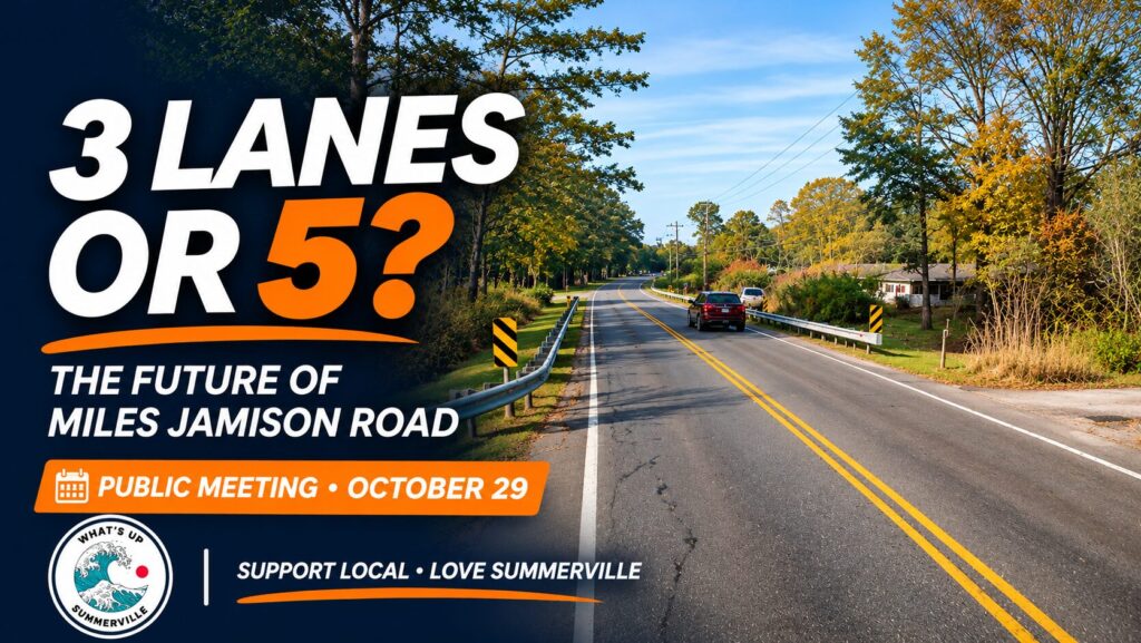
Five lanes, three lanes, or another approach? Dorchester County is preparing to present its preferred design for Miles Jamison Road, and residents will have another opportunity to weigh in on Thursday, October 29.
As Summerville continues to grow, conversations about development often lead to another question: can the roads supporting our neighborhoods keep up?
For residents who regularly travel Miles Jamison Road, that question is already part of everyday life. Dorchester County is evaluating improvements along approximately 3.3 miles of the corridor between Old Trolley Road and Ladson Road, with the stated goals of improving traffic flow, safety, and accommodations for people walking or cycling.
The project is entering another public-feedback stage. After presenting two roadway alternatives in 2025, the County plans to share updated information about its preferred design alternative at a public meeting on October 29, 2026.
Public Meeting — Thursday, October 29
Time: 5:00–7:00 PM
Where: Dr. Eugene Sires Elementary School
301 Chandler Creek Road, Summerville, SC 29485
Format: Drop in anytime; no formal presentation
Where Would the Improvements Take Place?
The study area stretches along Miles Jamison Road from Old Trolley Road to Ladson Road, including several important intersections and connections to surrounding neighborhoods. Proposed work includes roadway widening, intersection improvements, drainage infrastructure, and pedestrian and bicycle facilities.
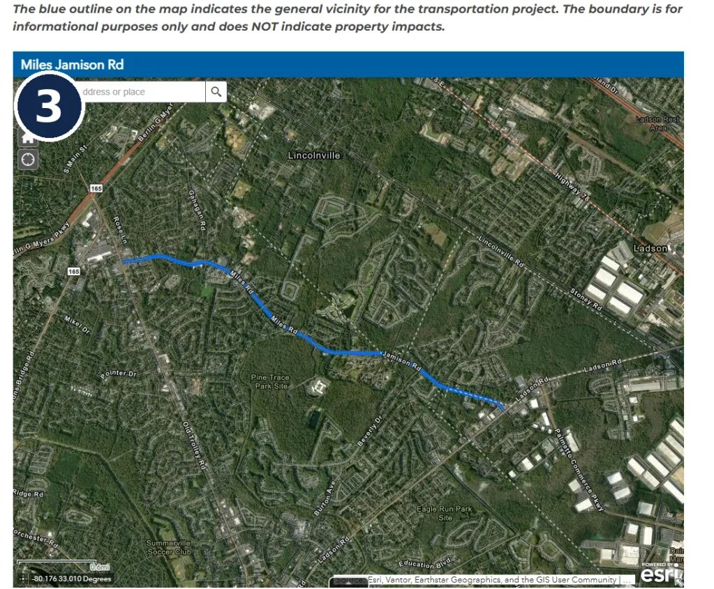
Project vicinity along Miles Jamison Road. Dorchester County notes that the blue outline is informational and does not identify specific property impacts. Source: Dorchester County Transportation Sales Tax Program.
Beyond traffic, the corridor includes established neighborhoods and community resources. Existing flood zones, streams, wetlands, schools, and other facilities are among the factors documented in the project’s environmental and community resource materials.
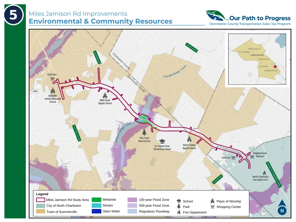
County mapping identifies natural features and community resources near the Miles Jamison Road study area; it does not by itself determine which properties would be affected.
Five Lanes or Three? The Alternatives
The two alternatives previously presented by the County share several features: a 15-foot center two-way left-turn lane, a 12-foot shared-use path, a 5-foot sidewalk, and curb-and-gutter drainage. The central difference is the number of through lanes and the overall footprint of the roadway.
Alternative 1: Five-lane roadway
This option includes two through lanes in each direction plus a center turn lane. It offers greater vehicle capacity and is designed with long-term traffic growth in mind. It also has the potential for greater property impacts, a larger construction footprint, and more changes to the character of surrounding neighborhoods.
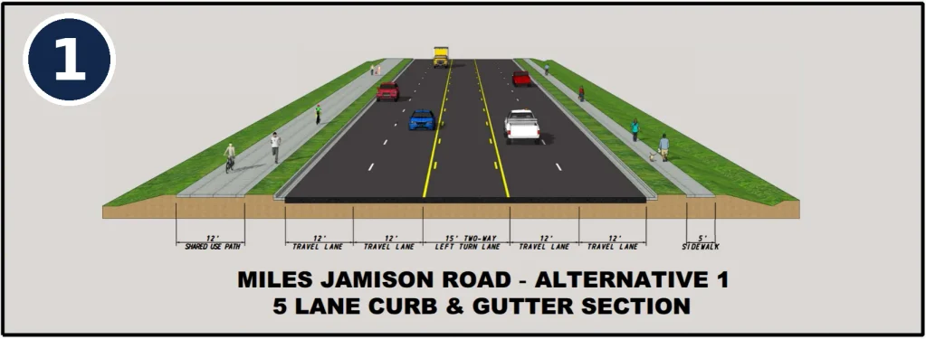
Alternative 1: five lanes, including a center turn lane, shared-use path, and sidewalk. Source: Dorchester County Transportation Sales Tax Program.
Alternative 2: Three-lane roadway
This option includes one through lane in each direction plus a center turn lane. It would generally have a smaller footprint, with somewhat reduced potential property and environmental impacts. The question raised in earlier feedback is whether that configuration would provide enough capacity as traffic increases in future decades.
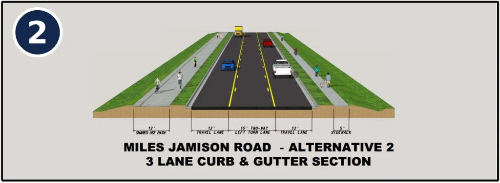
Alternative 2: three lanes, including a center turn lane, shared-use path, and sidewalk. Source: Dorchester County Transportation Sales Tax Program.
Important: These are the alternatives presented in the earlier project materials. Thursday’s meeting is intended to explain the County’s preferred design and provide another opportunity for public feedback.
What Do the Traffic Projections Show?
One of the central questions is how much either option would improve travel through the corridor. The County’s traffic analysis examines intersection performance under current and projected future conditions, including a 2050 scenario without improvements.
The analysis uses Level of Service (LOS) grades from A (free-flowing traffic) to F (heavy congestion or failing conditions), along with estimated average vehicle delay.
For example, at Miles Jamison Road and Chandler Creek Road, the published 2050 projections show LOS F under the no-build scenario. The five-lane alternative is projected to improve the intersection to LOS B in the morning and LOS A in the afternoon, while the three-lane alternative remains LOS F in both periods in that analysis.
That is one intersection, not a prediction for every location along the road. The broader graphic shows that projected outcomes vary by intersection and time of day.
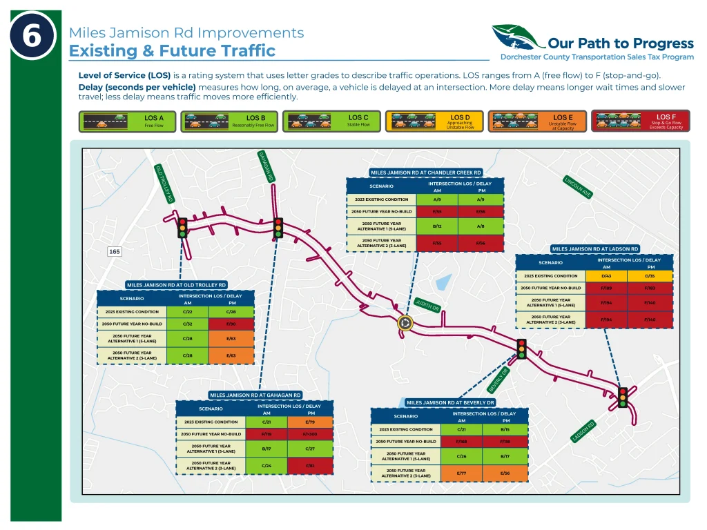
County traffic model comparing current conditions and projected 2050 traffic under no-build, three-lane, and five-lane scenarios. Forecasts are estimates, not current measured travel times.
What Did Residents Say the First Time?
The first public information meeting took place November 6, 2025. According to Dorchester County, 213 people attended and 131 comments were submitted during the comment period ending December 6, 2025.
38% — Preferred the five-lane alternative
34% — Preferred the three-lane alternative
16% — Preferred no build
The remaining responses were recorded as no preference (5%) or no response to the preference question (7%). In raw numbers, 49 respondents favored five lanes, 45 favored three, and 21 supported no build. The results reflect comments received, not a scientific survey of all residents.
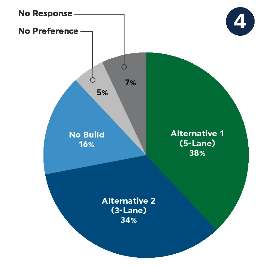
Preferences recorded in the County’s first public comment period. The two roadway alternatives received similar levels of support among respondents.
The comments also went well beyond lane counts. Residents raised concerns about:
- Congestion during school drop-off, pickup, and peak commuting hours
- Difficulty turning onto Miles Jamison Road from side streets
- Potential displacement of homes and businesses and right-of-way acquisition
- Neighborhood character, speeding, and traffic noise
- Pedestrian and bicycle safety near schools
- Flooding, drainage, wetlands, and mature trees
- Construction disruption and continued access to properties
The County’s published meeting summary describes residents with differing views on how best to balance traffic relief, safety, neighborhood access, and the physical impacts of widening.
When Could Construction Actually Begin?
The project remains in the design and public involvement process. The County’s published schedule, dated November 2025, shows right-of-way planning and acquisition and final design preceding construction, with construction anticipated around 2029 through 2032.
Those dates are planning estimates and may change as engineering, property acquisition, funding, and other project steps proceed.
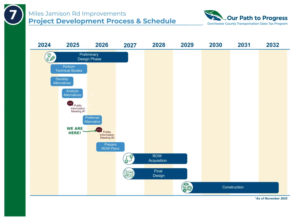
Dorchester County’s November 2025 project schedule, with the current public meeting stage highlighted by What’s Up Summerville. Future dates remain estimates.
How to Have Your Say
At the October 29 public meeting, residents can review the updated preferred design information, speak with the project team, and submit feedback. The meeting is a drop-in event from 5:00 to 7:00 PM, not a formal presentation.
Unable to attend? Dorchester County says a 30-day public comment period begins October 29 at 5:00 PM. Meeting materials and an online comment form will be available on the official meeting page afterward.
Miles Jamison Road — Public Meeting #2
Thursday, October 29, 2026 · 5:00–7:00 PM
Dr. Eugene Sires Elementary School
301 Chandler Creek Road, Summerville, SC 29485
What Do You Think?
Would five lanes better serve the area’s future growth? Could a three-lane design strike a better balance? Or are there particular intersections, safety improvements, or neighborhood concerns you believe deserve greater attention?
We welcome respectful discussion from residents who use Miles Jamison Road. And for those who want their input considered in the official process, Thursday’s meeting and the County’s public comment period are the opportunities to participate directly.
Support Local • Love Summerville.
Sources: Dorchester County — Miles Jamison Road Project · First Public Meeting Summary. All diagrams and maps credited to the Dorchester County Transportation Sales Tax Program; timeline marker adjusted for editorial clarity. Project information reviewed October 24, 2026.